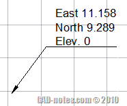
After I provided AutoLISP program to label coordinate automatically, I had some questions if it can show N, E, and elevation instead of just the coordinate text. So I made minor adjustment to the code.
This automatic labeling will create three lines of texts instead of just one line of xyz coordinate.

You can open notepad, copy and paste the code below, then save it as “lb.lsp” (type it with double quote when saving in notepad). If you want to show only Easting and Northing, you can delete the marked lines. Or replace East with E or X=, and so on.
You can read our tip on how to load AutoLISP program.
I hope this is useful.
; Automatic coordinate labeling

; Edwin Prakoso

; https://www.cad-notes.com

;

; Limitation

; ----------

; Will use current leader style and current units setting

; If you don't want to show elevation, then modify lines marked *
(defun c:lb (/ p x y z ptcoord textloc)

(while

(setq p (getpoint "

Pick Point: "))

(setq textloc (getpoint "

Pick Label Location: "))

(setq x (rtos (car p)))

(setq y (rtos (cadr p)))

(setq z (rtos (caddr p))) ;*you may delete this line

(setq x (strcat "East " x))

(setq y (strcat "North " y))

(setq z (strcat "Elev. " z)) ;*you may delete this line

(command "_LEADER" p textloc "" x y z "") ;*you may delete z

)

)
Want to create this program by your own? You can also adjust it to your needs. Try this AutoLISP exercise to create labeling coordinate program here.


Greetings Master. I have coordinate grid lines and need to generate labels on the individual “boxes”. Currently that only labels are those around the entire selected area. How do I do this?