• Home
  • Training Books
  • Subscribe to Our Email Newsletter
  • About
    • Contributors
    • Feedback
    • Contact
    • Privacy policy
    • Cookie Policy

CADnotes

CAD Tutorials and Best Practices for professionals and students

  • Featured
  • AutoCAD
    • AutoLISP
  • Revit
    • Revit Architecture Basic
    • Revit MEP Basic Tutorial
  • Inventor
  • MicroStation
    • MicroStation Basic Tutorial
You are here: Home / AutoCAD / Labeling Coordinate with Easting and Northing in AutoCAD

Labeling Coordinate with Easting and Northing in AutoCAD

November 26, 2010 by Edwin Prakoso 15 Comments

After I provided AutoLISP program to label coordinate automatically, I had some questions if it can show N, E, and elevation instead of just the coordinate text. So I made minor adjustment to the code.

This automatic labeling will create three lines of texts instead of just one line of xyz coordinate.
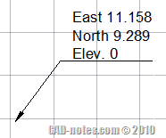
NE_labeling

You can open notepad, copy and paste the code below, then save it as “lb.lsp” (type it with double quote when saving in notepad). If you want to show only Easting and Northing, you can delete the marked lines. Or replace East with E or X=, and so on.

You can read our tip on how to load AutoLISP program.

I hope this is useful.

; Automatic coordinate labeling
; Edwin Prakoso
; https://www.cad-notes.com
;
; Limitation
; ----------
; Will use current leader style and current units setting
; If you don't want to show elevation, then modify lines marked *


(defun c:lb (/ p x y z ptcoord textloc)
(while
(setq p (getpoint "
Pick Point: "))
(setq textloc (getpoint "
Pick Label Location: "))
(setq x (rtos (car p)))
(setq y (rtos (cadr p)))
(setq z (rtos (caddr p))) ;*you may delete this line
(setq x (strcat "East " x))
(setq y (strcat "North " y))
(setq z (strcat "Elev. " z)) ;*you may delete this line
(command "_LEADER" p textloc "" x y z "") ;*you may delete z
)
)

Want to create this program by your own? You can also adjust it to your needs. Try this AutoLISP exercise to create labeling coordinate program here.

About Edwin Prakoso

I work as a Sr. Consultant in PT Cipta Satria Informatika. I've been using AutoCAD since R14 and Revit since Revit Building 9. I occasionally write for AUGIWorld magazine and I am also active in Autodesk discussion forum. I'm a member of Autodesk Expert Elite, an appreciation for individuals who give contributions to the Autodesk community.
Connect with me on twitter or LinkedIn.

Filed Under: AutoCAD, AutoLISP Tagged With: autolisp, label coordinate

0 0 votes
Article Rating
Subscribe
Login
Notify of
guest

guest

This site uses Akismet to reduce spam. Learn how your comment data is processed.

15 Comments
Inline Feedbacks
View all comments
Daud
Daud
7 years ago

Greetings Master. I have coordinate grid lines and need to generate labels on the individual “boxes”. Currently that only labels are those around the entire selected area. How do I do this?

1
Reply
« Previous 1 2
wpdiscuz   wpDiscuz

Featured

Doing computer exercise

How to pass Autodesk Professional certification

Do you plan to take Autodesk certification exam? Here are some tips and tricks to pass the exam. The questions are not difficult, but you need some tricks and strategy to easily pass it!

Recent Articles

  • Autodesk Construction Cloud Activity Log
  • Exporting AutoCAD Plant 3D Model to Navisworks
  • Autodesk Data Connector for Power BI is Now Available

Advertisement

New on CADnotes

  • Autodesk Construction Cloud Activity Log
  • Exporting AutoCAD Plant 3D Model to Navisworks
  • Autodesk Data Connector for Power BI is Now Available
  • Autodesk Forma Design Contest
  • Revit 2025: Toposolid Enhancements

Meet the Authors

avatar for
avatar for
avatar for
avatar for
avatar for
avatar for

Get Connected

CADnotes on FacebookCADnotes on InstagramCADnotes on TwitterCADnotes on YouTube

© 2009 – 2025 CADnotes · Feedback · Privacy Policy · Become an affiliate

wpDiscuz